
Shenandoah River State Park
This blog chronicles the hikes I've completed in the "Lee 333 Challenge". I haven't set a challenge deadline because I can't dedicate myself 100% to it. However, if the SNAP500 (or SHEN500) can be done in one year, I don't see any reason why a dedicated enthusiast couldn't complete the "Lee 333" in under a year also.
Today's Hike:
Distance: 7.94
Duration: 4.59
Ascent: 2310ft
PATC Difficulty: 191
Lee 333 Progress Summary:
Trails: 23 of 107
Trail Miles: 68.26 of 340.6 miles (272.34 miles to go)
Hiked Miles: 126.85 miles

Sleeping with my C-Pap machine in the back of my car
The "New" Milford Gap trail
For today's hike, I car camped Saturday night at the Shenandoah River State Park to help me get an earlier start. I arrived at the campground after 11pm to a beautiful crisp night sky with temperatures just above freezing. Sunday, I slept in, showered and began the short drive just over the river to the Milford Gap trail. Ha! I miscalculated, I had to drive a half hour south, over the river then a half hour north again to reach a point almost just across the river from the campground arriving at 11:30am.
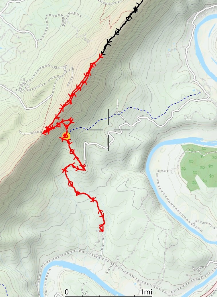
The local land owners have prohibited driving on 'their' Hazard Mill road just south of the Indian Hollow Road bridge (near the state campground). On the map below you can see that the campground is just 6 or 7 miles from Milford Gap via Hazard Mill road. I'm not sure how much of that Hazard Mill road is closed to the public. From the south, I drove all the way to Milford Gap via Page Valley road. I'll check it out of my next trip. I'd like to make a loop out of the upper Hazard Mill road and part of the "Old" Milford Gap trail.
I'm calling the Milford Gap trail by 3 names the "New Milford Gap Trail", The "Old Milford Gap Trail" and the "West Milford Gap Trail". The "New" part is the section that I hiked on this trip, it goes up the forest road then intersects with the "Old" section. The "Old" is the section in blue on the map below that parallels the red line I drew on left side. The "West" is the small red trail west of the Massanutten trail you can see on the map below just visible on the bottom left. I don't know what access exists for the "Old" and the "West" sections other than the intersection of the "Old" and the "New". That intersection is still there although marked with a sign that says "Wrong". See the map below where there is a yellow dot. I'll be exploring the area more later. If I can get there, I'll hike it.

Map of Shenandoah State Park and Milford Gap trails

A view west from the parking lot.

Parking on the forest road off Page Valley Road
Just before I left the parking area, a woman and a cute little puppy arrived. I waved and continued on. She quickly caught up with me and when she passed I got the chance to pet the puppy and exchange pleasantries.

Just a 100 yards up the forest road is a closed gate.

Typical view along the forest road

The road starts to climb

The turnaround for the end of the forest road

Well, not quite, there is still more road straight ahead at the turnaround.
This is the upper end of Hazard Mill Road.

The Milford Gap trail begins at the turnaround too, to the left.

Some views of the Shenandoah Valley begin as the trail gains some altitude.

There was mud under these leaves. On my way back I slipped because of this mud.
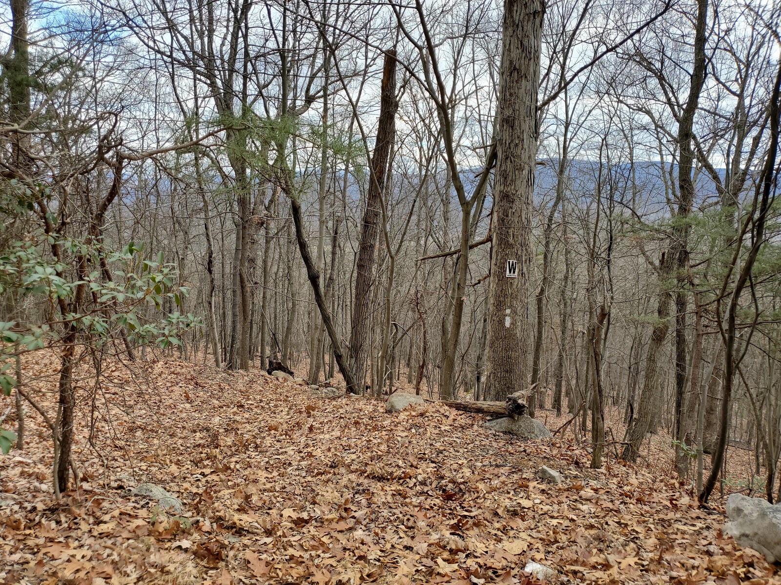
The "Old" Milford Gap Trail, and the "W Wrong" sign.


Still Climbing

A man and a yellow English Retriever passed me going down the trail in this section. We talked for a few minutes and I found out that he had completed the AT in 2016, the same year I made my attempt. His trail name is "Bone".


Ahhh, made it the intersection of Massanutten and Milford Gap "West"

The Massanutten trail intersection was off set from the Milford Gap "West" trail.

For some reason the Massanutten trail was moved off the ridge
and onto the steep eastern rocky slope.
and onto the steep eastern rocky slope.
I stopped for lunch in this section since there were many flat rocks right "on" the trail.
Lunch was liverwurst on fresh rolls with Gatorade to wash it down. I wasn't too cold, I was able to eat with just a heavy T-shirt on. Although after eating I had to don my coat again.

I found the trail relocation annoying, on my return trip I took the old route, much better.
I continued north on the Massanutten trail until I reached the point that I left off when hiking south on another trip and turned around for home. I took the original route of the Massanutten trail this time and could not figure out why they moved it off the ridge. It was perfect.
It got colder and cloudy and I got tired on the return trip, so I didn't take any more pictures. I made it back to the car about 4:40pm. A 5 hour hike, including a 20 minute lunch break.


